UAS: AERIAL PHOTOGRAPHY, MAPPING & GIS:
Taking 'Drones' to the Next Level:
There is no mistaking that 'drones' have gone mainstream, igniting a new level of creativity and innovation in the geospatial sector. Even after several years of offering acquisition and production services, we're still amazed at the capture options made available by 'drone' or UAS (Unmanned Aircraft Systems). In addition, it is inspiring to see our clients explore and experiment internally with their own UAS. Often, our clients come up with really innovative approaches, and we just help them connect dots in terms of processing and delivery - making their ideas reality. So, while we offer our own extensive UAS deployment, acquisition and data processing services, we also offer an established Mapping an GIS (Geographic Information System) knowledge base and capabilities that can help build value-add, accessibility and accuracy into your own UAS Aerial Photography acquisitions, production and project content.
Leveraging Experience:
Experience counts in the UAS sector, especially now. Like many new tech frontiers where momentum seems to supersede substance, our services offer the added benefit of an established foundation of experience, knowledge and capability (Learn More). In addition, we recognize that responsible flight operations are a large part of executing UAS projects safely and effectively. Access Geographic offers one of the strongest flight service teams in the industry within its diversified base of project history and extensive deployment capability. In addition, we carry (and exceed) the necessary FAA Certifications to work within existing rules and regulations for commercial sUAS flight operations. Moreover, Access Geographic is trusted innovator and one of only 75 firms in the United States granted a Nighttime Operations Waiver by the FAA on the first day Part 107 Ruling was initiated.
UAS Geospatial Deliverables:
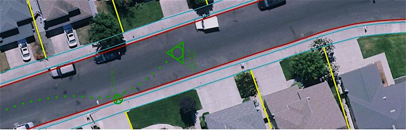
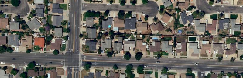
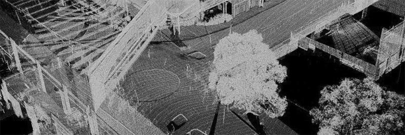
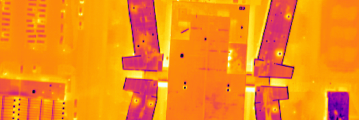
UAS offers a diverse range of product options including Photogrammetric, LiDAR and Multispectral Based Deliverables. Photogrammetric Based Mapping Systems (Learn More) support various applications from orthophotography and topographic mapping to highly detailed 3D modeling and immersion environments (Learn More). LiDAR Based Systems (Learn More) can provide a useful approach for detailed vegetation, terrain and structural 'surface model' driven projects. In addition, Multispectral Imaging Systems, such as Thermal (Learn More) and Color-Infrared (Learn More), offer a wide range of sensory applications from Gas Leaks to Structural Audits. Rotor-Based UAS also offer a unique capability to capture in 'True Horizontal' for detailed localized feature assessments, such a building edifice or elevated equipment inspections.
UAS + Geospatial Integration:
While UAS solutions offer amazing data collection opportunities, it is still only a single tool within a deeper geospatial arsenal. Integrating and leveraging the broader spectrum of geospatial resources available can significantly improve problem-solving and analytical value of UAS data. We honestly enjoy leveraging the capabilites of UAS acquisition to create useful, informative and effective geospatial resources for our clients. Feel free to explore our Experience & Case Studies, Services and Sector pages for more ideas and information.
UAS Training:
Whether in local government or private industry, having internal UAS training for your team can very useful. Access Geographic offers tailored on-site training options that focus on your area of need and deliverable requirements. Moreover, we will always be there to help. You can always leverage our base of processing and production capabilities to transform your acquisition data into effective, informative and actionable geographic information.
We Are Here To Help:
We are honestly excited about the capabilities for this innovative technology offers and look forward to talking with you about your experiences and taking your UAS data to the next level! Please feel to Contact Us!